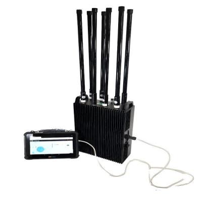
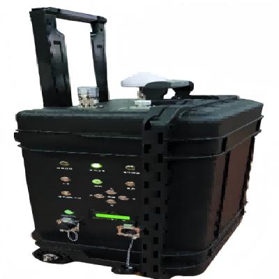
Live Electronic Mapping Radar Detection System Enhances Situational Awareness
Ⅰ. Product Description
The DroneIntegrated Monitoring, Mobile Terminal Control, Live Electronic Mapping Radar Detection System is a cutting-edge surveillance and reconnaissance solution designed to enhance situational awareness in dynamic environments. This advanced system combines drone technology, realtime electronic mapping, radar detection, and mobile terminal control to provide comprehensive monitoring and rapid response capabilities.
Ideal for security, defense, disaster management, and industrial inspections, this system delivers high-precision detection, live data transmission, and intuitive control through a userfriendly mobile interface. By integrating multiple sensing technologies, it ensures superior detection accuracy, seamless data fusion, and efficient operational coordination.
Whether deployed for border surveillance, critical infrastructure protection, or emergency response, this system offers unmatched versatility and reliability, making it an indispensable tool for modern security and monitoring operations.
Ⅱ. Product Features
1. Drone-Integrated Surveillance
Utilizes high-performance drones equipped with advanced sensors for aerial reconnaissance.Supports autonomous flight, waypoint navigation, and real-time video streaming.Enables rapid deployment in hard-to-reach or hazardous areas.
2. Mobile Terminal Control
Intuitive mobile app (Android/iOS) for real-time system control and monitoring.Remote access to live feeds, radar data, and electronic maps from any location.Supports multi-user collaboration with role-based access control.
3. Live Electronic Mapping
Generates real-time 2D/3D maps using GIS and satellite data.Overlays radar detections, drone footage, and sensor data for enhanced situational awareness.Supports offline map storage for operations in low-connectivity zones.
4. Advanced Radar Detection
High-sensitivity radar for detecting moving objects (vehicles, personnel, drones).Long-range detection with adjustable scan modes (short, medium, long range). AI-powered false alarm reduction and target classification.
5. Multi-Sensor Data Fusion
Integrates radar, drone cameras, thermal imaging, and other sensors for comprehensive monitoring.Automated threat detection and alerting system.
6. Weather Environmental Adaptability
Operates in extreme conditions (rain, fog, dust, low visibility).Ruggedized design for military and industrial applications.
7. Scalable Modular Architecture
Expandable with additional drones, sensors, or radar units.Compatible with third-party security and surveillance systems.
Ⅲ. Product Function
1. Real-Time Aerial Surveillance
Drones capture high-resolution images and videos, transmitting live feeds to the control center.Supports night vision and thermal imaging for 24/7 operations.
2. Dynamic Radar Tracking
Detects and tracks multiple moving objects simultaneously.Provides speed, direction, and trajectory analysis.
3. Live Electronic Mapping Geofencing
Displays real-time operational zones, restricted areas, and movement patterns.Geofencing alerts for unauthorized intrusions.
4. AIPowered Threat Recognition
Identifies suspicious objects (e.g., drones, vehicles, personnel) using machine learning.Reduces false alarms with adaptive filtering.
5. Mobile Command Control
Operators can adjust drone flight paths, radar settings, and sensor modes via mobile app.Push notifications for critical alerts.
6. Data Recording Playback
Stores mission logs, radar data, and video footage for post-analysis.Exportable reports for forensic review.
7. Multi-Drone Coordination
Supports swarm operations with synchronized drone movements.Automated collision avoidance and formation flying.
8. Emergency Response Mode
Rapid deployment for search rescue, fire detection, or security breaches.Automated distress signal tracking.
Ⅳ. Product Parameters
Working system | Phased array system/convolution Doppler |
Working frequency band | C wave band |
Full coverage | ≥90° |
Ply and glide | ≥18° |
For pedestrians | 100m~1.5km |
For mobile vehicles | 100m-3km |
For 5-10m mobile ships | 100m~3km |
Detection speed | L8km/h-130km/h |
Data interface | Wireless transmission (supporting RJ45) |
Rated dissipation | ≤ 55W (array surface) |
Positioning and orientation | It has automatic positioning and orientation function |
Working temperature | -20℃-55℃ |
Array size | 346mm×280mmx84mm |
Duration of flight | ≥ 4h (at room temperature, single cell) |
Installation time | ≤3min |
Weight | ≤12.0kg |
VI. Product Advantages
Target detection | Capable of real-time detection of moving targets, identifying unauthorized intruders or suspicious objects. |
Image acquisition | Equipped with high-definition image acquisition capabilities, it can obtain real-time image information from the surveillance area. |
Automatic network configuration | The system can automatically establish a network without human intervention, ensuring smooth communication between devices. |
Intelligent analysis | Conduct intelligent analysis of collected data, identify abnormal behavior, and issue alerts. |
Device positioning | Able to accurately determine its own location, making it convenient for monitoring and management. |
Data aggregation | Centralize and process data collected from multiple detection devices. |
data transmission | Transmit the processed data to mobile terminals or monitoring centers via wireless or wired means. |
Alarm integration | Integrate alarm information from different detection devices to avoid false alarms. |
Data storage | Store the transmitted data for subsequent analysis and querying. |
data transmission security | Use encryption technology to ensure the security of data transmission. |
The alarm is showing | Display real-time alert messages from the system to remind users to pay attention. |
Data storage | It can store data collected by the system, making it convenient for users to view at any time. |
Equipment management | Users can remotely control and manage the system through mobile devices. |
electronic map | Display surveillance areas and device locations intuitively through an electronic map. |
Information exchange | Users can interact with other devices or individuals through mobile terminals. |
Data transmission security | nsure secure communication between mobile devices and the system. |
VI. Company Style
VII.Corporate Events